


Running a surveying business is highly rewarding, but it comes with multiple technology considerations. As a surveyor, you need to choose the right tools for the job, and knowing which tools are most suitable for your projects can be a big hurdle when it comes to growing your business.
In this blog, Hexagon’s Andrea Biasion explains the different benefits of the 3D laser scanners in Leica Geosystems product portfolio – which includes tools designed for simplicity, speed, accuracy, precision and effectiveness in all environmental conditions.
Firstly, what is reality capture?
Reality capture is the process of digitising the physical world. Professionals can use different measurement technologies to collect accurate 3D data for use in various software applications and workflows. The physical world can be digitised and represented in a 3D environment using 3D sensors, becoming the basis for decisions in different fields of work. Then, decisions based on the digital models can inform concrete actions in the physical world.
What are the applications of reality capture?
From traditional building construction and crime scene investigation to city mapping and volumetrics, reality capture applications are almost endless. The end-to-end workflow for reality capture is divided into four steps; capturing data, processing data, managing data and creating the end deliverables. The first – capturing data in the field – is what surveyors are most used to doing. The workflow’s other three phases are sequential and mainly performed in the office. The processing of the data is where the data is imported, registered and modelled. The management of the data is where the data is made available to create the final deliverables. At the end of the workflow, the data is put to work for all professionals that consume the data.
What devices are the perfect match for reality capture?
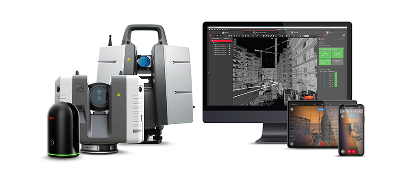
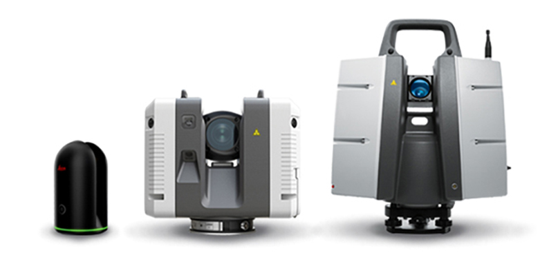
There are three flagship devices for the job; The Leica BLK360 Imaging Laser Scanner, the Leica RTC360 3D Laser Scanner and the Leica ScanStation P-Series.
To compare, the BLK360 is the smallest and lightest imaging laser scanner of its kind. It’s simple to use and captures full-colour panoramic images overlaid on a high-accuracy point cloud. The RTC360 allows users to automatically pre-register point cloud data in the field to conduct quality control checks quickly. Its streamlined process for reality capture makes it suitable for non-surveying users and allows individuals to make better-informed decisions on-site, even on complex projects. Finally, the ScanStation P-Series is a range of versatile, survey-grade 3D laser scanning solutions. These scanners deliver speed, accuracy and range for demanding scanning projects, making them perfect for creating as-built representations and capturing the 3D geometry of civil infrastructure.
What’s the difference between these 3D laser scanners?
The environment is a significant factor in deciding which laser scanner to invest in, especially if the user will be operating under extreme temperatures. The three laser scanners have a varied temperature range – the ScanStation P-Series can operate from -20°C to +50°C, whereas the BLK360 can operate between +5°C and +40°C and the RTC360 can operate between -5°C and +40°C.
Then there are differences in speed and resolution. The RTC360 has the highest scan speed at two million points per second, followed by the ScanStation P-Series at 1 million points per second and the BLK360 at 360,000 points per second. The ScanStation P-Series offers the highest resolution. The maximum range measurable also differs between them – the BLK360 is 20-60 metres, the RTC360 is 40-130 metres, and the ScanStation P-Series is 70-1,000 metres.
For software, all three laser scanners connect with the Leica Cyclone FIELD 360 mobile device app for data acquisition in the field. This means that each laser scanner is able to capture, register and examine scan and image data automatically. The user interface combines easy handling of complex calculations with graphical user guidance, which offers a remarkably straightforward user experience, even suitable for novice users.
How do I know which 3D laser scanner is right for my project?
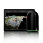 Each scanner has its own unique offering, so choosing the right laser scanner comes down to the day-to-day projects your team works on. The BLK360 is perfect for relatively small-scale documentation applications where images are as important as accurate 3D data. It’s suitable for outdoor and indoor applications and works well in congested areas due to its maximum portability and simplicity. Users who have no experience using laser scanning technology can easily adopt this scanner due to its easy interface and one-button operation. What’s more, because it’s very light at only 1kg, it’s perfect for projects requiring a device that’s easy to handle.
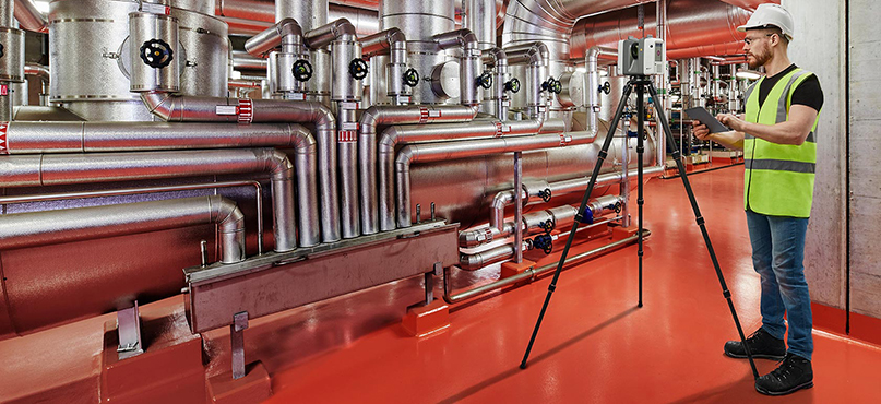
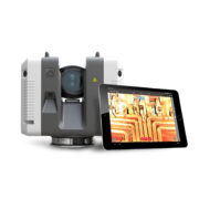 Meanwhile, the RTC360 is a scalable solution for larger projects: think mapping something the size of an industrial plant. The laser scanner is perfect for projects where productivity and data quality are key factors, such as construction planning or public safety. It embodies a Visual Inertial System using five cameras and other sensors, allowing the scanner to track its position while moving from setup to setup. This streamlines all of the registration and processing operations, making the full end-to-end workflow faster and more optimised. Whether you operate in light or dark environments, the RTC360 can collect a full-dome HDR of pictures in less than one minute and has the highest scanning speed at up to two million points per second. It’s the perfect companion for challenging environments.
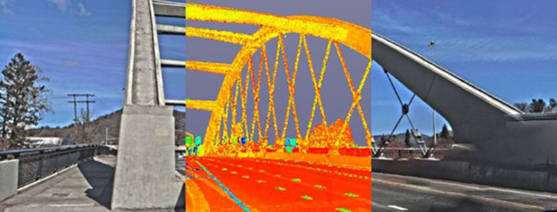
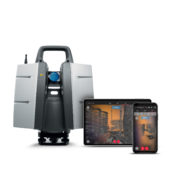 Finally, the ScanStation P-Series offers the right solution if your team requires highly reliable and accurate results to feed into a range of workflows. They are high-end laser scanners adopting surveying functionalities like target measurement, troubleshooting and inspections. These scanners are ideal if your team is operating in the harshest conditions with extreme temperature ranges; our customers use them in, for example, bridges, highways, mines, airports and dams. Due to their superior measurement range, they will be the instruments of choice when covering larger areas where data quality over a long-range is a key factor. In summary, the ScanStation P-Series are weatherproof, robust and perfect for teams that require best-in-class data quality.
To learn more, watch Andrea Biasion’s presentation from Intergeo 2021, 3D Laser Scanners: A Perfect Tool for Surveyors.

Andrea Biasion
Product Manager, Laser Scanning
Reality Capture Division
Our range of industry-leading 3D laser scanners will allow you to improve your workflows, offer new and better services, be more productive and stay competitive. To embrace this technology and bring your business exciting opportunities, visit our Pure Surveying website.